3. The division or sub-division of any site into plots for the erection of buildings will be in accordance with the layout plan approved by the Authority.
4. The planning should provide for easy circulation and the shape of the plots should be regular as far as possible.
5.
(a) The minimum size of a plot in the Residential Neighborhood shall be 200.67Sq.m. with a minimum width of 9.14m.
(b) The plots in the Light Industry Area shall be as per the layout plan approved by the Gandhidham Development Authority vied Drg.No. ATP 1/60 dated 18.4.1960.
(c) The plots in the Godowns Area shall be as per the layout plan approved by the Gandhidham Development Authority vide Drg.No. ATP 18/61 dated 4th December, 1961.
(d) The pattern of roads and Railway lines in the Manufacturing Area shall be as per the layout approved by the Gandhidham Development Authority vide Drg.No. ATP 18/61 dated 4th December, 1961.
(e) The minimum size of a plot in the Composite Zone shall be 133.78 Sq.m. with the minimum width of 9.14m.
(f) The plots in Triangular piece of land, North of Khanna Market, Sardarganj, reserved for Godowns, Light Industries and Meat Market shall be as per the Layout plan approved by the Gandhidham Development Authority vide permission No. 1627/LP/7, dated 13th June, 1972 as Amended vide letter No. 4GDA(236)/72/1122 dated 19th September, 1972.
6. The land widths for roads shall be as under:
(i) 60.96m. in case of arterial roads.
The arterial roads in the Master Plan of Gandhidham are detailed as under:
(a) Portion of the Kandla Ahmedabad National High Way along with the service road on either side towards the East of the Township.
(b) The Trunck road connecting two areas named, Adipur and Sardarganj (Link Road).
(c) The proposed BhujState high way forming the Southern boundary of the Township.
(d) Proposed road in the center of the township leading to the Aerodrome and bisecting the Link Road vide item (b) above.
(ii) 45.72m. for road round the Industrial Areas.
(iii) 24.38m. for Collector roads within Industrial Sectors.
A Collector road is a road which collects traffic from the Sector and leads to the arterial road or to a road round the Industrial Area.
(iv) 18.29m. for minor roads within the Industrial Area.
A minor road is for the local traffic within the Industrial area and leads to the Collector Roads.
(v) 24.38m. for periphery roads round the residential neighborhood units.
(vi) 18.29m. for collector roads in the residential area.
A collector road is a road in the residential area, which leads to local traffic into a periphery road.
(vii) 12.19m. for minor internal roads in the residential neighborhood units.
A minor road is a road for the local traffic and leads the traffic to a collector road.
(viii) 45.72m. for periphery roads on West and South of BusinessCenter.
(ix) 24.3m. for internal Roads in business Center.
(x) 18.29m. for Collector Roads and 12.19m. for internal roads in the Area of Composite Zone.
(xi) The road widths in Offices Area shall be as per the approved layout plan.
(xii) Roads widths in case of Triangular piece of land, North of Khanna Market, Sardarganj, reserved for Godowns, Light Industries and a Meat Market shall be as under:
(1) 24.36m. towards the North-East side 12.19m. towards Western and Southern sides.
(2) 12.19m. for minor Roads within the said piece of land.
Note:– The Cross-sections for Roads except National High Way and the State High Way mentioned in this Directions shall be as per the Cross-sections approved by the G.D.A. from time to time.
Notwithstanding above, the said Cross- sections will not be applicable in case of Roads constructed prior to the issue of this amendment
7 (a) No layout scheme for the sub-division of land in any neighborhood unit shall provide for an aggregate for more than 60 percent of the gross area for the purpose of allotment of plots for residential and commercial purpose and less than 40 per cent of the gross area in aggregate for roads, open spaces, gardens, recreational grounds, schools and other Civic amenities and public places.
7 (b) No layout scheme for sub-division of lands in the Light Industry Area, Godowns Area and Manufacturing Area shall provide for an aggregate of more than 65% of the gross Area for the purpose of allotment of plots and less than 35% of the gross area in aggregate for roads and open spaces, gardens recreational grounds, and public amenities such as Bank, Post Office, Fire brigade, Dispensary, Cruch, Canteen etc.
7 (C) (a) Along Galpadar road towards North 400m from center of road is earmarked for industrial purpose. Some pockets will be earmarked for Commercial-cum-service oriented purpose.
(i) The Survey Nos. of Village Galpadar and Survey Nos. falling within 1000mt from gamtal area of Village Galpadar are hereby declared for residential purpose.
(ii) The following Survey nos of Village Galpadar towards west of Kandla – Aerodrome road are hereby declared for light industry/commercial purpose:
1 to 11, 97/1-2, 101 to 109, 111 to 123 and Government waste land.
(b) The land towards west of V 15 to V 26 shown in Village Map of Meghpar Kumbharadi up to existing Railway line from Adipur to Anjar is earmarked for Residential purpose and the remaining land between V 15 to V 26 referred to above up to road in front of Spinning Mill leading to Anjar is earmarked for Industrial purpose except the Survey Nos. 44, 45, 46/1, 46/2, 46/3, 47, 48/1, 48/2, 49, 50, 53, 54, 55, 56, 59, 120/1, 120/2, 120/3 of Village Meghpar Kumbharadi are hereby used for establishment of an educational complex.
(i) The Survey Nos. 116/4, 117/1 & 117/2 (amalgamated Survey No. 116/4) of village Meghpar Kumbharadi falls in Industrial zone now hereby used for residential purpose.
(ii) The Survey No. 104 of Village Meghpar Kumbharadi having area 40233 Sq. mt is hereby declared for residential purpose.
(c) The pocket up to border of master plan towards west of District 5 upto Mundra road within the Gandhidham master plan area is earmarked for residential purpose. The remaining unplanned area of survey numbers within the master plan towards eastern side of Mundra road is planned for residential purpose.
(d) 200m vide strip along southern border of master plan from KPT’s water pipe line upto KFTZ is earmarked for Residential purpose. Area towards North of said pipe line upto Master Plan is earmarked for Residential purpose. Area between Zones Nos. 2 & 3 of Village Kidana up to Road leading to Kidana from AntarjaluptoVillage Antarjal is earmarked for Residential purpose.
(i) The Survey Nos. 99 to 121, 147 to 151, 155 and 162 of Village Kidana are earmarked for Residential purpose.
(ii) The Survey Nos. 8, 9/1 to 3, 14/1, 15, 32, 33, 34 to 98, 152 to 154, 170 & 171 of Village Kidana are earmarked for Residential purpose.
(e) The area consisting of Village Shinai falling within GDA’s jurisdiction is earmarked for residential purpose, except the area towards North and Government waste land towards both side of Shinai – Anjar road and quarry areas allotted by the Collector Kachchh and area towards West of Shinai Dam and Government waste land towards south of Shinai Dam of Village Shinai within GDA’s Jurisdiction, is
hereby earmarked as green belt or the same can be allowed for agricultural purpose also.
(i) The roadplan of zone no 1 of Village Shinai shall be as per drawing given here under:
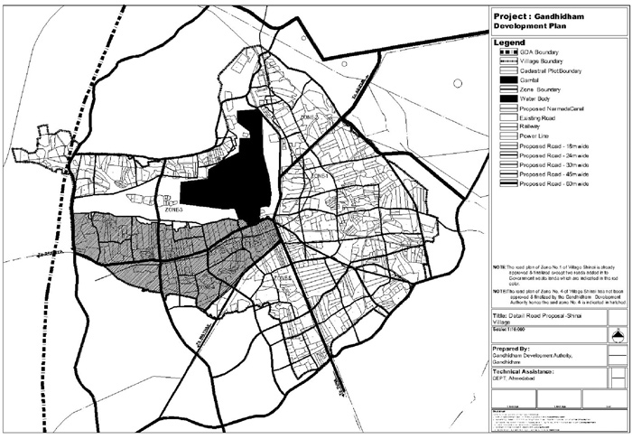
NOTE: The road plan of Zone No. 1 of Village Shinai is already approved & finalized except two roads added from Government waste lands which are indicated in the red colour.
NOTE: The road plan of Zone No. 4 of Village Shinai has not been approved & finalized by the Gandhidham Development Authority hence the said zone No. 4 is indicated in hatched.
(f) and (f) (i) Deleted